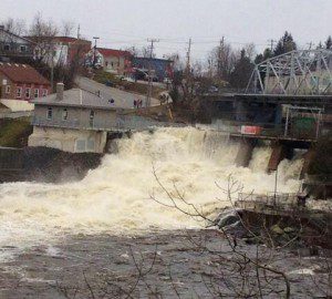
I could hear it before I could see it. It sounded a bit like a strong wind blowing through the trees. But it was a constant white-noise sound. Then I could feel it. The earth beneath our feet seemed to vibrate. Not an earthquake, but as I walked onto the wilderness bridge, I could feel it being pounded.
The force of surging water seemed to rattle the steel and stone of the structure to its core. I stood there at the centre of the bridge spanning the river where it pours over a large drop known as Victoria Falls and I marvelled at Nature.
“This is as close as I’d ever want to get to a tsunami,” I suggested to a one of my travelling partners. “What power.”
Last weekend, as my canoeing party made its way south on the Black River, just north of what Dalton Digby Wildlands Provincial Park (in today’s City of Kawartha Lakes region,) we saw the tail end of all that flooding we’ve been hearing about. In recent weeks, the water levels from Huntsville in the north to Bracebridge in the west to Bancroft in the east have crested with devastating impact. Dozens of villages and towns in the region have weathered rising waters caused by a quick thaw, heavy residual snow, additional rains and plenty of ice jams. Some have called it the hundred-years flood; in fact, official accounts say the water levels in the area are the highest since record keeping began in 1876.
I’m not sure about the technicalities, but last Saturday morning, when my canoeing buddies and I put into the Black River near Vankoughnet (east of Bracebridge), the river was higher than any of us had ever seen; and our annual canoe trip goes back to 1985.
Normally, our paddle down the Black is pretty leisurely. Most years we have to scrabble down fairly steep banks of the river, pack our canoes on a pretty severe grade and gingerly hop into the water craft. Generally, our two-day trip takes us along about 30 kilometres of river (20 km as the crow flies) through swifts and eddies peppered with rocks and sandbars that keep us on our toes and occasionally force us to line or portage around low-water spots. Most of our canoes have the battle scars to prove it.
Last weekend, however, the water had crested a day or two before and the river was just off the roadside put-in. We merely stepped from the roadside that had been underwater just a day or two directly into our canoe seats and began to paddle. Once into the water, the normally docile current immediately pulled us into its southbound flow.
And at every bend in the river, where we previously had lazily paddled through the corners, often we had to dig like Olympic rowers (or as best we could imitate them) to avoid being swept into one bank or the other. None of us was dumped in two days of travel on the river, but the power of the faster-than-normal flow was greater than I ever remember. And it was my 15th or 16th trip.
What impressed us even more was the state of our traditional campsite, near Campbell’s Falls (about the halfway point). Just below the shallow falls, where there has always been a low-lying beach for our makeshift kitchen and tenting area, we found a new layer of silt probably 18 to 24 inches deep stretching the full length of the beach – several hundred feet long and stretching back 30 or 40 feet into the woods. I know the dimensions because each year my job at the campsite is to relocate the stones that make up our mortar-less rock oven for our cook.
This year, I “guestimated” where the old oven site was and we began to dig. It took a bit of trial and error, but we eventually found our old cooking spot nearly two feet down. And that new vast beach of silt from the river had been deposited there just since the spring thaw, the break-up of the river ice and the rise and fall of the recent flood. Again, I marvelled at the power of Nature.
We spotted further evidence of the whack this spring flood had delivered in the debris along 30 km of riverside. Almost all the way down we saw orphaned docks, crumpled outhouses, paddleboats, and cottage toys of every shape and description. It reminded me of images of Japan’s tsunami waste deposited on Canada’s Pacific coast last year after drifting across the Pacific. There were no motorcycles or ocean containers along our Black River.
But we watched a discarded broken canoe get sucked under a pile of driftwood and disappear for good; it made us realize and respect even more the waterway that had given us a pleasurable ride through the wilderness over the weekend.
“Watch and beware,” somebody said.